|
|
|
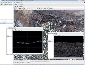
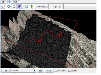
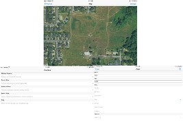
WFDS Input File Creator & Data Viewer
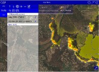
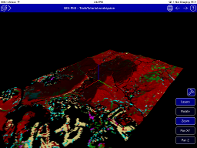
The Wildland-Urban Interface (WUI) Fire Dynamics Simulator (WFDS) Input FIle Creator is a cross platform java application developed to create WFDS input files from Geographic Information System (GIS) data sets as well as integrate WFDS simulation outputs in a GIS environment. This app was developed as part of a National Institute of Standards and Technology Fire Research Grant to Geospatial Measurement Solutions, LLC. Key application functionality is as follows:
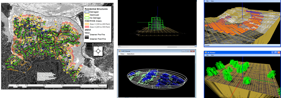
- Loading and visualizing in a 2-D and 3-D environment WFDS spatial data inputs representing terrain,
fire barriers, boundary fuels, fuel elements, trees, buildings, fire lines, devices, domains and imagery.
- Visualizing raw LIDAR point clouds in 2-D, 3-D mode.
- Creating and placing spatially, WFDS inputs representing devices, trees, fire lines and domain areas.
- Creating WFDS input files from input data over specified geographic extents.
- Visualizing created WFDS input files in context of geospatial input data.
- Re-sampling (i.e. changing the grid cell size) geospatial input data to different WFDS grid cell resolutions to allow for creation of WFDS input files at various scales.
- Visualizing WFDS simulation outputs.
- Creating custom scripts for extending the application.
- Running WFDS-LS1 in a standalone environment.
Due to funding cuts distribution is monitored. Contact dmgeo@gmsgis.com for more information.

|
|
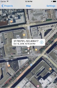
 GIS-FMI (GIS - Fire Model Integrator) GIS-FMI (GIS - Fire Model Integrator)
This app was developed as part of a National Institute of Standards and Technology Fire Research Grant to Geospatial Measurement Solutions, LLC. This application integrates the Wildland-Urban Interface (WUI) Fire Dynamics Simulator (WFDS) Level Set 1 (LS1) fire model into a mobile environment. This is a proof of concept application for running the WFDS-LS1 in a self contained mobile application.
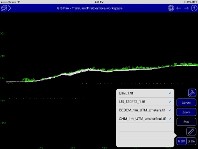
The application also contains functionality to load raster and vector GIS files including GeoTiffs, ERDAS Imagine img files, shape files and other outputs of WFDS. Data can be viewed in 2D, 3D and profile environments. Custom symbologies for data sets can be created and legends can be viewed on the screen. Basic measuring tools are also available for the application. Shapefiles can be directly edited within the application and custom configurations can be created. These shapefiles along with custom workspaces can be distributed via various Cloud based platforms or through iTunes. Custom data entry configurations can be created using the application. Data can also be compressed and zipped and downloaded or upload to or from the application through iTunes™.
|
|
COPY BREAK
|
|
|
|
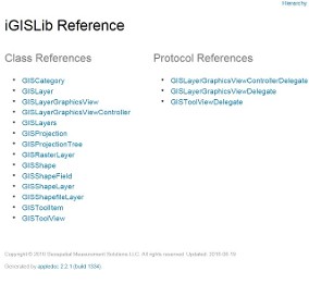
iOS GIS Library
The iOS GIS Library is a set of Objective-C classes and protocols for integrating GIS data into iOS applications. Display and loading of shapefiles and GeoTiffs is facilitated through this library along with handling of projections and other viewer controls. Access to shapefile attribute tables is allowed as well as other functionality described in the library reference founded in the program download below.
|
|
|
|
 iGeoSchema iGeoSchema
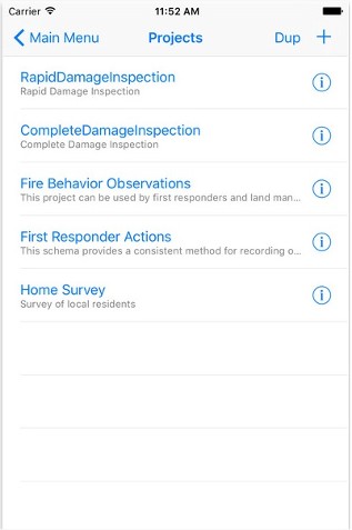
This application was developed as part of a National Institute of Standards and Technology (NIST) Fire Research Grant to Geospatial Measurement Solutions, LLC. iGeoSchema is an application designed to be used with the iGeoData application. IGeoSchema creates custom data collection schemas that can be implemented on numerous iOS devices using the iGeoData application for field or office data collection. Both applications specifically address the need for electronic data collection for WUI and wildland environments by those not trained in geospatial science and technology. Some predesigned data collection schemas are available for performing WUI Homeowner Structure Mapping, Fire/Smoke Behavior Observations, First Responder Actions and a NIST WUI 1 Assessment. These custom schemas can be loaded to iGeoSchema and altered or enhanced. While this application was developed with WUI and wildland fire data collection in mind, any custom data collection schema can be created using the iGeoSchema.
The schema is created as an XML file and custom schemas can be created that support fields with various data types (e.g. integer, text, image, date, pick list, or multi choice fields). Data can be grouped into categories and attributes can be set to be repeating when used in iGeoData.
|
|
 iGeoData iGeoData
This application was developed as part of a National Institute of Standards and Technology (NIST) Fire Research Grant to Geospatial Measurement Solutions, LLC. iGeoData addresses the need for electronic data collection for WUI and wild land environments by those not trained in geospatial science and technology. An associated application, iGeoSchema can be used to create custom data collection schemas that can be distributed and loaded to the iGeoData application. Some predesigned data collection schemas are available for performing WUI Homeowner Structure Mapping, Fire/Smoke Behavior Observations, First Responder Actions and a NIST WUI 1 Assessment. While this application was developed with WUI and wildland fire data collection in mind, any custom data collection schema can be implemented.
|
|
|