(208) 818-2152                                                                                                                   dmgeo@gmsgis.com

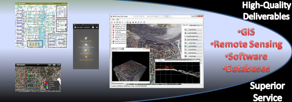
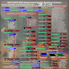
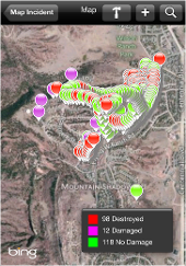
Geospatial Measurement Solutions, LLC:  Custom software development; database maintenance and development; remote sensing analysis, data collection, mobile technology implementation, and scientific analysis and documentation.

GEOGRAPHIC INFORMATION SYSTEMS, RELATIONAL DATABASE MANAGEMENT SYSTEMS, SOFTWARE ENGINEERING, REMOTE SENSING, FEATURE EXTRACTION, MOBILE TECHNOLOGY.


Services

GMS staff provide a variety of services related to Database Design and Maintenance, Mobile Application Development, Complete Software Life cycle Management, Geospatial Data Collection, Analysis and Dissemination, Scientific Analysis and Writing.


  • Universal Modeling Language Implementation allows for scalability.
  • Design meets industry specific needs with efficient integration with software.
  • Documentation provides reference and means to track changes.

Database Design & Maintenance

GMS staff have experience with the majority of spatial and tabular database platforms available on the market today, both commercial and open-source.  Designing efficient databases that meet the need of project are key to any information technology (IT) project.  Changes are to be anticipated and the structure must facilitate this while reducing required code changes.  Our combined IT experience helps us to best meet the need of our client while providing a structure that meets industry specific end-user requirements.


Customized Damage Inspection Add.
  • Apple and Android (Beta)
  • Links Images to Points
  • Customizable configurations.
  • On and Offline Editing.
  • Integration with Other Devices.
  • Integration with Cloud

Mobile Technology Development

Whether you need Android, Apple, Windows Mobile or some other custom solution GMS staff can meet your projects need.  We have the proven experience to customize third party software like ArcPad™ or ArcMobile™ or develop customized solutions to meet your projects needs.  We maintain a fleet of mobile collection devices including all Apple mobile devices and many Android devices including Samsung Galaxy and Droid Razr.  Whether you need custom solutions, maintenance of your mobile equipment or advice on implementation GMS can meet your needs


      • Geospatial Data Viewer.
      • Integration with LIDAR and Other Geospatial Data.
      • 3D Viewer, Profile Viewer.
      • Export inputs to fire models for other analysis and simulations.

        Software Design, Development & Documentation

        GMS has the experience to develop simple or extremely complex software on mobile devices, desktops, or the web.  Our staff has experience customizing ESRI, GE Smallworld, Manifold, QGIS, ENVI, ERDAS Imagine and all Microsoft Office applications.  Whether the problem is simple or complex we can meet the need. 

          • Windows, Mac, Linux
          • Mobile Systems
          • Web Programming
                 
              
        • Configured and implemented hardware for CALFIRE damage assessments.
        • Developed and installed data collection software.
        • Provided technical support and integrated data.
        • Performed image processing and analysis

          Data Collection

          GMS can meet your geospatial data collection needs. 

          • More information coming soon!!!
                             
          Highlighted Project (2007 Witch Fire Case Study)
          • Combined Geospatial Science with Industry Specific Analysis.
          • Complex Geospatial Analysis.
          • Highlighted need to assess exposure and usefulness of geospatial technology for assessing exposure to flame and embers.

          Geographic Information Science & Technical Writing

          GMS staff can turn geospatial data into information pertinent to the discipline being examined.


          Remote Sensing Analysis and Data Processing

          Multispectral Data


          Multispectral imagery is prevelant throughout our everyday experiences from navigation systems to news features.  Extracting information from this imagery takes the right tools and expertise.  GMS can turn your multispectral data into information pertinent to your business needs.

          Landcover Classification from Multispectral Imagery


          LIDAR


          Light Detection and Ranging (LIDAR) data has numerous applications across multiple disciplines.  GMS provides services in:

          • LIDAR Processing
          • LIDAR Algorithm Development
          • LIDAR Training

          We know how to take your LIDAR data and transform it into valuable information.


          UAS


          Unmanned aerial systems (UAS) have exploded on the market place.  With any democratization of technology there are growing pains.  GMS knows how to process UAS data from photogrammatry to UAS LIDAR, GMS has the expertise to get the job done.

          UAV Acquired Pre-Fire and Active Fire Processed Imagery

          ©2013 Geospatial Measurement Solutions, LLC - 2149 Cascade Ave. Ste. 106A PMB 240 Hood River, OR 97031, USA  541-436-4486  dmgeo@gmsgis.com

          Geospatial Technology, Development, Implementation and Maintenance Services.