|
Integrating Geographic Information Science (GISci) with the Study of Wildland-Urban Interface (WUI) and Wildland Fires: Modeling, Remote Sensing and Data Collection.
(National Institute of Standards and Technology Fire Research Grant 60NANB11D173)
SITE NAVIGATION
|
BACKGROUND & OVERVIEW
The Wildland-Urban Interface (WUI) is a term used to describe the location where flammable structures and flammable vegetation co-exist resulting in potential for destruction to both environments from fire. Typically, flammable vegetation in a WUI setting is thought of as wildland vegetation, though residential or treated vegetation can ignite. Wildlands, as with the WUI, have been defined in various ways (e.g. National Wildfire Coordinating Group, California Department of Forestry and Fire). Wildlands are of concern, in context of the WUI, when they have potential to burn. WUI areas are of concern because of the loss of life, hazards to first responders and homeowners, and damage and destruction to the built environment that has occurred in WUI environments due to fire.
This damage and destruction has been described as increasing over recent decades (Blue Ribbon Panel Report on Wildland-Urban Interface Fire, 2008). Additionally, increased development in WUI areas increases potential situations where a destructive WUI fire might occur. Finally, climate change has been described as producing conditions that could result in increased wildland fire (Climate Central, 2016).
|
|
|
 |
Posters & Presentations
|
|
|
|
|
Wildland fires have drawn attention in recent years due to their large size; loss of life; the health concerns due to smoke; and the cost involved in mitigation, suppression, reclamation and other related costs. Not only must communities and first responders be adaptive to new knowledge on fire behavior and resulting improvements to WUI and wildland mitigation advice but they must be resilient after a disaster. Acquiring adequate information before, during and after a disaster is essential to achieving this resiliency. Integrating this information in a community setting with involvement from stakeholders can go far in achieving disaster resilience for WUI communities and can be applied to management of wildland environments.
Lessons learned in the WUI can and should be integrated with resilience information from other disasters. Removal of all vegetation from the hillslope, for example, might produce a property mitigated from the danger of wildfire. These homes, however, might slide down the slope during significant precipitation events without proper slope stabilization, often achieved with vegetation. It is, therefore, an interdisciplinary effort to protect first responders, homeowners, and the built and natural environments from wildland fire.
|
|
Adequate pre-fire, active-fire and post-fire information can aid scientists and engineers in gaining a better understanding of wildland and WUI fires. Combined from various sources, information about pre-fire, active-fire and post-fire conditions can then facilitate the development of appropriate field and lab experiments to ensure conditions represent real-world exposures found at wildland and WUI fire events. These experiments might aid in validation and development of the next generation of physics-based fire models such as the Wildland Fire Dynamics Simulator (WFDS). In the United States (US), the above described integrated approach is embodied through the National Institute of Standards and Technology (NIST) Fire Risk Reduction in Communities Program as shown in Figure 1.
|
|
|
|
|
Additionally, the difficulties with acquiring during fire measurements in real-world WUI and wildland environments results in the need to model fire behavior with validated models in these environments to gain an understanding of exposure conditions that otherwise cannot be determined. Physics-based fire models have gained attention in recent years but currently there is limited information regarding fire characteristics for even low intensity fires, resulting in physics-based fire models being in the early stages of validation and development. Finally, development of a measurement scale to rate a communities potential exposure from a wildland fire as described in Maranghides and Mell (2013) provides a framework to help deploy WUI and wildland fire measurement science, thereby; providing support for major fire research needs identified in Pellegrino et al. (2013) and Mell et al (2010). |
Advances in geospatial technologies (remote sensing, global positioning systems and communication technologies) and other technologies (e.g. Manzello et al. 2010) have resulted in the potential for better assessing WUI and wildland pre-fire, during-fire and post-fire conditions to gain an understanding of exposure conditions (e.g. Maranghides and Mell, 2012) existing in diverse WUI environments. Integrating geospatial technologies with fire models might consequently provide a better understanding of fire behavior and result in more appropriate assessments of exposure conditions a WUI or wildland environment might potentially receive or produce from a fire. More wide spread adoption of Geospatial Science and technologies as applied to the study of WUI and wildland fires could also aid in a more prevelant understanding of the problem by stakeholders and provide a framework for delivering data to future scientists and engineers.
|
Figure 1: The NIST Integrated Approach to study of the WUI (Maranghides).
|
| Physics-based fire models, however, require accounting for the three-Dimensional (3D) distribution of natural and human made fuels as well as meteorological boundary conditions. Additionally, understanding WUI and wildland phenomena requires data collection at multiple scales. Coarse scale WUI damage and destruction information at a national or regional level are required for regional planning and ongoing monitoring of the problem while fine scale mapping of WUI and wildland damage and destruction is required to understand the specific environments in which these fires occur. Micro-scale damage assessments are required for Fire Protection Engineers to understand structure vulnerabilities. Also, delineation of 3D fuels is required for validation of physics-based fire models in outdoor experiments and might be required for implementation of science based WUI mitigation advice. Ultimately, the integration of all the above data and more is required to gain an understanding of exposure conditions occurring in these fires. |
|
The tools, technologies and methods of the Geographic Information Sciences (GISci) can support NIST and other efforts by providing a means to integrate WUI and wildland spatiotemporal data at various scales in a consistent fashion. Not only can the data integration help to portray the complex fire behavior that might occur at WUI and wildland fires, it can provide an understanding of the state of the art of various measurement sciences in regards to the spatiotemporal resolution of the phenomena being integrated. For example, if a respective fire line can only be captured at a horizontal resolution of 2 meters but fuels can be captured at 15 centimeter resolution, efforts can and should be focused on developing sensors to capture the fire line at a finer resolution. Integration of data in a Geographic Information System (GIS) is a powerful means to evaluate data of different scales. Data integration in a spatial environment can also provide new insights into the WUI and wildland fire problems such as demonstrated in a recent study of the 2012 Colorado Waldo Canyon Fire (Maranghides et al. 2015) resulting in more representative field and laboratory experiments and model simulations.
GISci also provides a means to implement WUI and wildland mitigation advice that incorporates scientific information using modern tools and technologies to better assess interactions in the built and wildland environment and design efficient and effective solutions. GISci, however, can only go so far in qualification and quantification of the exposure phenomena occurring in a WUI or wildland environment. Adequate field measurements characterizing pertinent aspects of the phenomena are required with advances in various measurement science disciplines needed (e.g. active fire remote sensing). Validated models are then required to take the integrated data and assess and analyze the physical characteristics of exposure phenomena. Validating physics-based fire models will require numerous lab and field experiments representing pertinent exposure conditions found in WUI and wildland fires.
The NIST integrated approach supported by the tools, techniques and methods of GISci can provide a framework for better understanding WUI and wildland exposure phenomena. A better understanding of WUI exposure phenomena could facilitate the development of appropriate test methods for building materials and landscaping and allow for the development of more logically implementable and effective WUI mitigation advice. Integration of geospatial data at field experiments provides an initial step for data analysis and incorporation into physics-based Fire Models such as WFDS. Finally, the above described integrated approach can take advantage of the commonly understood medium of cartographic productions (static and interactive) that are often interpretable to a wide audience allowing for a productive transfer of information to stakeholders when studying and addressing the complex issues present in the WUI and wildlands.
Focus AREAS
Integrating GISci into the study of WUI and wildland fires initially requires a basic understanding of the spatial context of the WUI problem. At its simplest the WUI problem can be broken down into three components required for a WUI disaster:
- Initial ignition of some fuel element (i.e., built environment or wildland fuels).
- Eventual fire spread through wildlands or other combustible vegetative fuels.
- Fire spread from the wildlands to the built environment and consequent damage and destruction to the built environment.
In others word, fires can start anywhere in the world where the conditions for combustion can be met, sometimes these fires ignite wildlands, which in turn ignite or come close to the built environment. The above, is at its simplest the WUI fire problem. An example of the traditional WUI problem is shown in Figure 4. Ultimately, if there is no wildland or vegetative fire, structures cannot burn from the fire and there is no WUI disaster. If there are no structures burning from wildland fire there is no WUI disaster. The above three components describe the spatial context of WUI disasters. Detailing the spatiotemporal nature (fuels, topography, weather coupled with sensing of during fire and smoke behavior and component processes) of the above phenomena, along with documenting human actions during the fire (prescribed or natural), might go far in providing an understanding of WUI fire behavior and the resulting response of the built environment. The NIST/USFS Exposure Scale provides a framework for developing an understanding of the above phenomena.
|
|
|
|
|
|
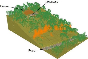
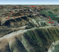
Figure 4. Example of the traditional WUI problem where fire spreads through vegetative fuels to expose residential structures. The above example is visualization of a WFDS simulation around a house in the Trails Community in San Diego, California.
|
|
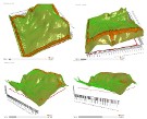
Building the Exposure Scale requires mapping the 3D structure of fuels, topography and weather. Mapping the spatiotemporal extent of WUI and wildland phenomena needs to occur in both two-dimensional (2D) and 3D space with time being the fourth dimension required for most mapping efforts. An understanding of the spatiotemporal nature of WUI and wildland destruction can be facilitated in a 2D environment through simple delineation of address center points affected by WUI fires allowing for understanding of the general location of destructive WUI fires. Destruction to vegetative elements is best accomplished through a combination of aerial and ground based remote sensing with appropriately stratified ground sampling. Understanding fire behavior and associated component processes is far more complicated and might be facilitated through validation of physics-based fire models in controlled and repeatable experiments.
|
This NIST Fire Research Grant focuses on the integration of GISci into various aspects of the study of the WUI and wildlands to enhance understanding of these environments and support various aspects of the NIST Fire Risk Reduction in Communities Program. As such, this Fire Research Grant has three primary focus areas. These three primary focus areas are discussed in more detail below.
|
Focus Area 1: Integrating Geographic Information Systems with Fire Models
Integrating GIS with fire models is required to move current fire models beyond applications in simulated environments. Even simulated environments should eventually be delineative of real-world conditions found in WUI and wildland environments representative of the problems. Additionally, validation of physics-based fire models will ultimately require incorporation of 3D geospatial data representing terrain, fuels, instrument locations and meteorological phenomena at different resolutions. Limitations of various empirical fire spread models, both in terms of underlying algorithms and data inputs, could be better understood through comparisons with experiment and real-world characterizations of fire behavior. Consequently, a key focus area for this research grant is the integration of GIS with empirical and physics-based fire models. Read more about integrating GIS with WUI and wildland fire models...
Focus Area 2: WUI and wildland Data Collection
Data collection in WUI and wildland environments involves capturing the spatial information described above (i.e., fuels, topography, weather coupled with sensing of during fire behavior and the human actions occurring during the fire). The Fire Disturbance Continuum as described by Jain et al (2004) provides a framework to understand the temporal aspects of the data to be collected. Advances in geospatial technologies and mobile devices have allowed for more efficient and effective collection of information in WUI and wildland environments (e.g. Maranghides et al 2015). This focus area involves examination of various technologies and techniques for enhanced collection and derivation of WUI and wildland data. Remote Sensing science and technology also has provided significant advances in WUI and wildland data collection and is discussed in the section described below. Read more about WUI and Wildland Data Collection...
Focus Area 3: Remote Sensing in the WUI
R emote sensing of WUI and wildland environments provides opportunities to collect information regarding the pre-fire, during-fire, post-fire and response environments. Other readily available remote sensing technology like Google Street View, and Bing Maps Oblique Imagery can all provide valuable information for assessment of WUI affected communities. Commonly available remote sensing data from satellites can be acquired of many WUI effected areas in a relatively rapid manner. The use of Unmanned Aerial Systems (UAS) also have potential for rapid acquisition of information regarding WUI affected communities. This type of information can not only aid in initial assessments but can serve as a base for scientific studies as well as a historical record of WUI incidents. Read more about the use of remote sensing in the WUI...
|
WUI & Wildland Study Sites
Three study sites are being utilized for examining integration of GIS into the WUI and wildlands. WUI and wildland study sites examined by NIST, the Texas Forest Service and the United States Forest Service (USFS) are being used to derive data for potential model simulations. More information is described for each site below.
Southern California
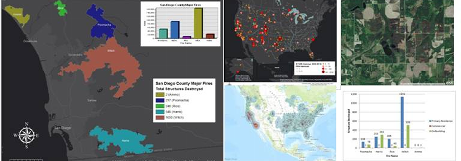
(2007 California Witch Fire)
The 2007 Witch Fire was one of the largest WUI disasters in California history. The Trails a Rancho Bernardo Community was studied by NIST and contains data for model simulations........
|
 |
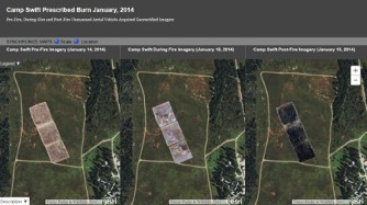
Camp Swift Texas Prescribed Burns
In January of 2014 prescribed burns took place at Camp Swift in Bastrop County Texas. GMS was called in to evaluate improvements to geospatial technologies as well integrate geospatial data into formats capable of being read by fire models.
|
|
Additional Study Sites
Data was also processed/acquired for additional study sites including Joint Base Lewis McChord, the 2011 Texas Tanglewood Fire and the 2012 Waldo Canyon Fire......
|
|
|