Geospatial Measurement Solutions, LLC: Custom software development; database maintenance and development; remote sensing analysis, data collection, mobile technology implementation, and scientific analysis and documentation.
Fire Models and Geographic Information Systems (GIS) (National Institute of Standards and Technology Fire Research Grant 60NANB11D173)
BackgroundIntegrating GIS with fire models is required for validation of physics-based fire models. Even applications of physics-based fire models in simulated environments should be representative of real world conditions found in WUI and wildland environments typical of the problems or appropriate to the question being asked by the model. Additionally, validation of physics-based fire models in a research burn environment will ultimately require incorporation of 4D geospatial data representing terrain, fuels, meteorological phenomena and instrument locations co-loacted in space and time. Identification of limitations of empirical fire spread models, both in terms of underlying algorithms and data inputs, might also be better acheived through comparisons of integrated spatiotemporal data describing experiment and real-world characterizations of fire behavior with empirical model simulation results. Consequently a key focus area for this research grant is the integration of GIS with empirical and physics-based fire models.
In particular, this project is developing, enabling and implementing geospatial technologies to allow for integration of geospatial data into the Wildland-Urban Fire Dynamics Simulator (WFDS). This technology could be used to aid in integratation of geospatial data inputs into WFDS to facilitate model validation; identify as practical potential case studies for modeling activities in actual WUI or wildland events (e.g. Maranghides et al. 2011; Maranghides et al. 2013); and provide general guidance on geospatial data integration with empirical and physics-based fire models. The technology is anticipated to have uses beyond the WUI and wildlands for various geospatial activities including Light Intensity Detection and Ranging (LIDAR) data visualization in an integrated environment. FIre model gis linkage needs assesssment
The technology being developed as part of this project could also be used to integrate other fire model information but currently, the focus is on integration with WFDS. There are two general models possibly appropriate for modeling of WUI and wildland fires contained within WFDS:
WFDS-PB is an offshoot of the National Institute of Standards and Technology (NIST) Fire Dynamics Simulator (McGrattan et al. 2012). WFDS-PB extends FDS beyond structural fuels to account for terrain and vegetation (Mell, 2010). WFDS-Level Set (WFDS-LS) began as a single implementation as described in Rehm and McDermot. Currently the WFDS-LS module consists of four different implementations. LS1 and LS2 are empirical models being equivalent in approach to FARSITE. LS3 and LS4 include varying degrees of physics. Users should contact Dr. William Mell for more information on using WFDS-LS. WFDS-LS is being used to gain a better understanding of the limitations of empirical based fire models. Little is known about the situations and conditions under which empirical fire model use is appropriate. Comparison of model simulation results between physics-based and empirical fire models might provide information on appropriate and inappropriate uses of empirical fire models and the conditions under which the models cannot be relied upon. The validation of physics-based fire models is therefore essential to gaining a better understanding of fire behavior and which tools can be used under what conditions. Integrating geospatial data into physics-based fire models is required for any moderately complex landscape (i.e., beyond flat and completely homogenous fuels). Initial work for the grant began by discussing fire model needs with Dr. William Mell of the United States Forest Service (USFS). Based on these and other discussions three key needs were identified as follows:
Various analyses were conducted and prototype software applications developed based on the above general needs. Terrain simulation tool
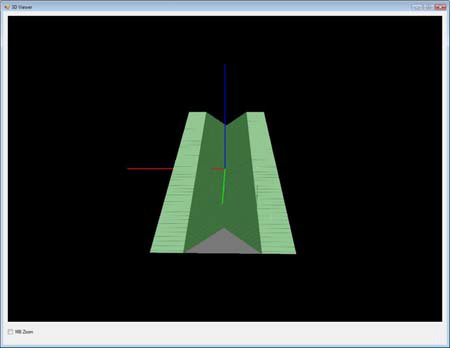
The project begin with an examination of a program to create WFDS inputs from simulated terrain and vegetation. A simple terrain and vegetation simulation program was initially created using C#.net to perform the following key functions: ? Simulating terrains described by planes, parabolas and canyons. ? Placing, interactively, vegetation as fuel elements or boundary fuels. ? Creating WFDS input files from simulated terrain and vegetation. Examples of simulated vegetative landscapes created with the program are shown in Figure 1.
Figure 1. Examples of simulated terrains created with the terrain simulation application. The above software development demonstrates the complexities involved in creating simulated environments, particulary regarding simulation of vegetation and topography concurrently. Also, many environments can be simulated in a GIS or smoothed or recreated, to some extent. Furhermore, additional research conducted for this study identified the following software that could aid in creation of WFDS inputs from simulated environments: Many of the tools above apply to simulated environments but the research conducted for this study found no tools for integration of geospatial data with WFDS. There were, however, historic tools such as GEOWFDS, which used the Enviornmental Systems Research Institute (ESRI) software to create WFDS input files. This software was not maintained and only functioned on historic versions of ArcGIS for Desktop (ArcGIS Desktop 9.3) model/GIS integration strategies
Initial research described above coupled with experience by the Principal Investigator for this project in developing historic WFDS/GIS linkages identified the need for a simple software package to serve as a loose coupling between WFDS and any GIS platform. Creation of real world inputs for validation, evaluation and potential use of physics-based fire models such as WFDS and FIRETEC will require use of GIS software to fully integrate data. A GIS platform provides the tools required for manipulation of the base data. Validation, evaluation and use of process based fire models such as WFDS and FIRETEC are in the early stages. A number of processing and data massaging techniques could be required for proper use of inputs such as high resolution digital elevation models, canopy height models and field based fuel sampling. GIS packages can handle these data manipulations as the science progress with the WFDS/GIS Linkage software facilitating use by modelers for data transformations and visualization of those transformations in context of the base data without the need to learn the complexities of a GIS system. The integration of GIS with various environmental models is a well studied problem with classification of these integration strategies generally being as follows:
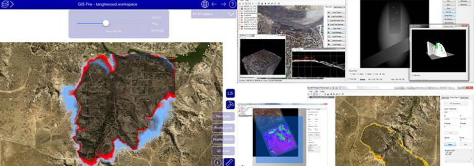
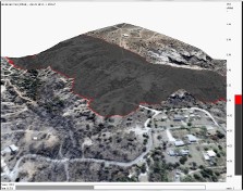
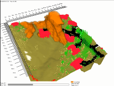
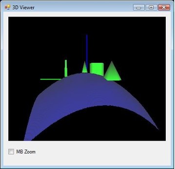
This project developed solutions for a loosely integrated system for integrating geospatial data and technology with WFDS-PB and a fully integrated system for integrating geospatial data and technology with WFDS-LS. Systems were created on both desktop and mobile operating systems with all systems containing basic geospatial data viewers and integrators with the following key functional requirements of the software: ? Loading and visualizing in a two-dimensional (2D), three-dimensional (3D) and a profile view environment WFDS spatial data inputs representing terrain, fire barriers, boundary fuels, fuel elements, trees, buildings, fire lines, devices, domains and imagery. ? Visualizing raw LIDAR point clouds in 2-D, 3-D mode. ? Creating WFDS input files from input data over specified geographic extents. ? Transforming WFDS outputs to GIS data formats. ? Re-sampling (i.e. changing the grid cell size) geospatial input data to different WFDS grid cell ? Visualizing WFDS simulation outputs. Initially, for this project a prototype Micorsoft Windows based desktop application was developed in C#.NET demonstrating the above functionality. Subsequent use by fire modelers resulted in the need for the production application to operate in a cross-platform environment (Windows, Mac and Linux). The development of this prototype tool was conducted to help modelers describe and solidify desired functionality of the Model/GIS Linkage as well as to facilitate creation of WFDS input files for various study areas. A tutorial describing the use of this software can be downloaded here. This software allowed for the rapid creation of WFDS input files for a number of study sites as shown in Figure 2 below.
Figure 2. Examples of WFDS-PB and WFDS-LS simulations demonstrating the integration of geospatial data with WFDS. All integrations were performed using the prototype software described above. The prototype software described above facilitated the development of production cross-platform software. This cross-platform software facilitates all of the above functionality on a Windows, Mac or Linux Operating System as well as integration and viewing of much larger geospatial datasets compared to the prototype software described above. More information about algorithms and geospatial data transformation techniques to WFDS can be found here. |
©2013 Geospatial Measurement Solutions, LLC - 2149 Cascade Ave. Ste. 106A PMB 240 Hood River, OR 97031, USA 541-436-4486 dmgeo@gmsgis.com