Geospatial Measurement Solutions, LLC: Custom software development; database maintenance and development; remote sensing analysis, data collection, mobile technology implementation, and scientific analysis and documentation.
Remote Sensing in the Wildland-Urban Interface (WUI) (National Institute of Standards and Technology Fire Research Grant 60NANB11D173)
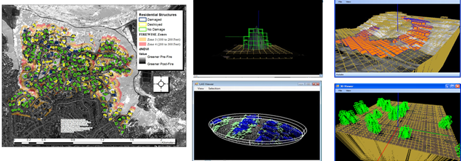
Remote sensing is an important measurement technique for identifying key characteristics of the Fire Disturbance Continuum in WUI and wildland environments. Remote sensing has been used to assess vegetative characteristics of pre-fire and post-fire WUI and wildland environments (Maranghides et al., 2013; Maranghides et al., 2015). Assessment of WUI and wildland fire behavior can also be assessed using remote sensing techniques (Maranghides et al., 2015). Finally, remote sensing has been used to assess post-fire effects (Lentile et al., 2006). Remote sensing has a number of advantages for assessment of WUI and wildland environments including:
There are also disadvantages to remote sensing for assessment of WUI and wildland environments including:
It must also be remembered that, in many cases, remote sensing will require ground data for accuracy assessments and to build relationships between remotely sensed measurements and extracted phenomena (e.g vegetation fuel load from LIDAR). Remote sensing techniques are also essential to deriving fire model inputs and fire model validation data sets. Both empirical and physics-based fire models require continuous inputs of fuels, terrain and boundary conditions representing meteorological conditions present in the area. Remote sensing provides the only means for acquiring some of this information over large areas for landscape scale modeling. Nonetheless, as demonstrated at the Camp Swift Research Burns, field measurements of wind, fuels fire behavior and other information is still required for validation of fire models. This project utilized remote sensing for assessment of WUI and wildland environments for all aspects of the Fire Disturbance Continuum.
|
©2013 Geospatial Measurement Solutions, LLC - 2149 Cascade Ave. Ste. 106A PMB 240 Hood River, OR 97031, USA 541-436-4486 dmgeo@gmsgis.com