Geospatial Measurement Solutions, LLC: Custom software development; database maintenance and development; remote sensing analysis, data collection, mobile technology implementation, and scientific analysis and documentation.
Fire Models and Geographic Information Systems (GIS) (National Institute of Standards and Technology Fire Research Grant 60NANB11D173)
Fully embedding wfds-ls1 on desktop and mobile devices
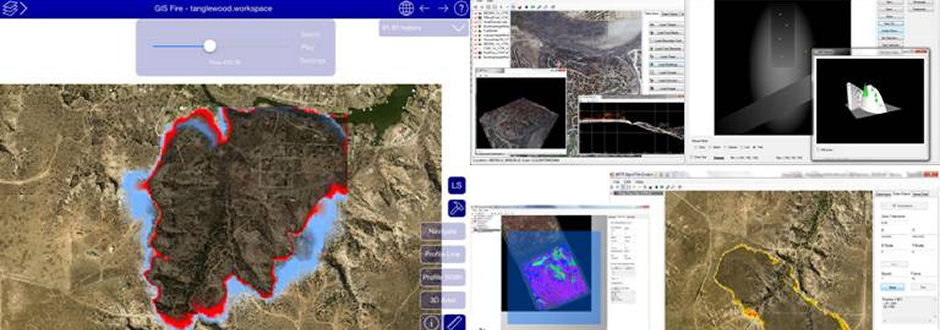
Early in the project life cycle it was requested by fire modelers that GMS examine fully embedding WFDS-LS within a mobile environment. The following key functional requirements for this mobile application were identified as follows: ? Visualizing shapefiles, ERDAS Imagine, GeoTiff, and web mapping services. ? Navigating and querying of data sources. ? Symbolizing shape and raster data sets by attribute values. ? Viewing cross sections of digital elevation models and other three-dimensional (3D) data sources. ? Visualizing 3D information overlaid with imagery. ? Adding multiple layers to the 3-D and profile views with ability to toggle the visibility of these layers. ? Editing and creating features. ? Saving workspaces for later use. ? Creating WFDS input files from input data over specified geographic extents. ? Viewing multiple WFDS simulation output files in the same view. ? Embedding WFDS-LS1 algorithms into application. ? Animating outputs from WFDS simulations. ? Zipping a project workspace for distribution to collaborators. ? Creating custom data collection schemes and sharing these amongst applications. Custom data collection schemes include the following: o Single, Single Choice, Multi-Choice or Image Fields. Screen shots of the 2D, Profile, and Three-Dimensional (3-D) window of the mobile GIS-FMI (Fire Model Integrator) are shown in Figure 3 below. Figure 3. Screen shots of key functional requirements found in the GIS-FMI mobile application developed for iPads. The full testing and procedures utilized for fully integrating WFDS-LS1 into the prototype desktop application and GIS-FMI are described in this report. The integration of WFDS-LS1 also occurred in the cross platform application. GIS-FMI is available for download free of charge on the App Store. This effort highlighted the possibility of implementing WFDS-LS1 as well as WFDS-LS2 in a mobile environment but speed of execution on a mobile device remains an issue. Fully embedding WFDS-LS3 and WFDS-LS4 on a mobile device would be difficult if done outside of the FORTRAN development environment due to the complexity of the code base. |
©2013 Geospatial Measurement Solutions, LLC - 2149 Cascade Ave. Ste. 106A PMB 240 Hood River, OR 97031, USA 541-436-4486 dmgeo@gmsgis.com